 IMAS Metadata Catalogue
Queensland University of Technology (QUT)
Type of resources
Topics
Keywords
Contact for the resource
Provided by
Years
-
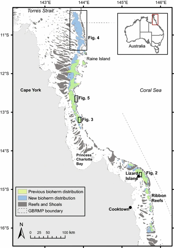
Sediment derived from the decomposition of Halimeda algae is a major contributor to the tropical back-reef carbonate depositions. Halimeda bioherms occur extensively on the northern Great Barrier Reef (GBR), Australia. This dataset represents the most complete, high-resolution spatial mapping of the extent of northern GBR Halimeda bioherms, based on airborne lidar and multibeam echosounder bathymetry data. Three distinct morphological sub-types are described: reticulate, annulate, and undulate. The northern GBR bioherms cover an area of 6095 km2, three times larger than previous estimates.
-
This seagrass habitat map was produced by the ACEAS Seagrass working group as part of the seagrass habitat risk modelling effort. The map identified seagrass presence based on 1) on the NISB (National Intertidal-Subtidal Benthic) Habitat Map created by the University of Tasmania for a partnership between the Department of Climate Change and the National Land and Water Resources Audit, 2) UNEP WCMC Seagrass map 2005.
-
This seagrass habitat map was produced by the ACEAS Seagrass working group as part of the seagrass habitat risk modelling effort. The map identified seagrass presence based on 1) on the NISB (National Intertidal-Subtidal Benthic) Habitat Map created by the University of Tasmania for a partnership between the Department of Climate Change and the National Land and Water Resources Audit, 2) UNEP WCMC Seagrass map 2005
-
This seagrass habitat map was produced by the ACEAS Seagrass working group as part of the seagrass habitat risk modelling effort. The map identified seagrass presence based on 1) on the NISB (National Intertidal-Subtidal Benthic) Habitat Map created by the University of Tasmania for a partnership between the Department of Climate Change and the National Land and Water Resources Audit, 2) UNEP WCMC Seagrass map 2005, 3) publications/reports and 4) expert knowledge/personal observation.
-
This seagrass habitat map was produced by the ACEAS Seagrass working group as part of the seagrass habitat risk modelling effort. The map identified seagrass presence based on 1) on the NISB (National Intertidal-Subtidal Benthic) Habitat Map created by the University of Tasmania for a partnership between the Department of Climate Change and the National Land and Water Resources Audit, 2) UNEP WCMC Seagrass map 2005, 3) publications/reports and 4) expert knowledge/personal observation. This nationally aggregated seagrass presence/absence habitat map was produced from individual state-based habitat maps (see child records) for the purpose of publication to the AODN Data Portal.